Maps Available at Wilmette Public Library
Digitized Maps
Our online map collection is available here. Many of our smaller and most used loose maps have been digitized and are available on our Local History site.
Bound Maps & Atlases
Bound map volumes are kept on the Atlas stand in the Local History Room. Please contact the Local History Librarian at ejohnson@wilmettelibrary.info if you'd like to view these maps.
Top Shelf
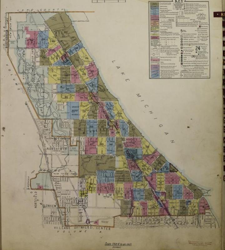
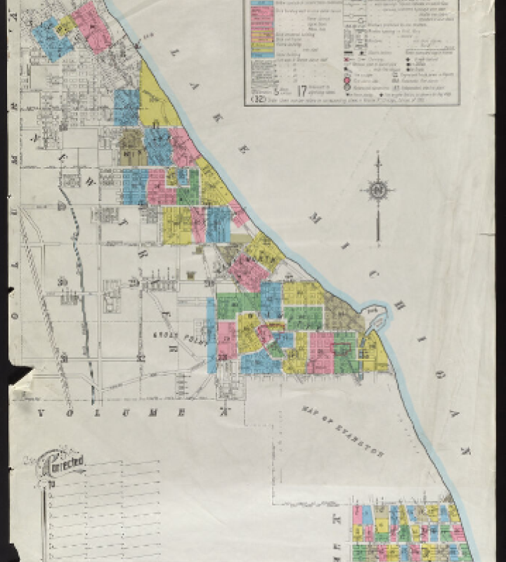
- Sanborn Insurance maps of Chicago Illinois: Volume J. Sanborn Map Company, 1914 with additions to June 1936. The volume includes Wilmette locations east of Ridge Ave.; Kenilworth; Winnetka; Chicago locations south of Howard Ave., east of Western Ave., north of Devon.
Shelf 1 & Shelf 2
- Ownership index to Wilmette, July 1, 1936—two copies of basic index. The ownership indexes include a map of Wilmette, and an index of the owners of each property, including property descriptions and owner names. Supplements show changes in property owners. One copy of the below listed supplemental indexes divided between the two basic indexes.
- July 1, 1936-September 1, 1936
- July 1, 1937-December 1, 1942
- December 1, 1942-May 1, 1944
- May 1, 1944-January 1, 1951
- January 1, 1951- March 1, 1955
- Temporary supplement Dec. 1955
- March 1959
- March 1, 1955-March 1, 1959
- October 1960-March 1962
Shelf 3
- Chicago Zoning Maps. Also contains assorted suburban maps. No date.
- 1876 Atlas of Illinois (Reproduction). Includes map of Cook County.
Shelf 4
- Untitled volume showing hand drawn maps of sewer pipes laid in Wilmette.
Shelf 5
- Ownership indexes to Kenilworth, 1924, with supplements to 1962. (2 volumes)
- Official atlas of New Trier Township. Clear view maps compiled and furnished by Sidwell Studio. Hand written entries dates April 1, 1950—April 1955.
Individual Maps in Map Box
Maps are listed by map number. If a map is available online, a link has been provided to our Local History site. If you'd like to look at one of these maps, please contact the Local History Librarian at ejohnson@wilmettelibrary.info, with the number of the map you'd like to view.
| Map # | Name & Description of Map |
|---|---|
| 1 | Manila folder containing maps drawn by Charles C. Henderson. 8.5 X 11 inches. Contains maps numbered 1.1 to 1.12. |
| 1.1 | The Growth of Wilmette: geological formative data [Sept. 1949] |
| 1.2 | The Growth of Wilmette: government survey of 1818 and map of the area’s drainage system |
| 1.3 | The Growth of Wilmette: Lake Chicago’s changes that developed the Wilmette area |
| 1.4 | Road from Chicago to Gross Point. Taken from a survey made in 1840 by William Milburn of St. Louis, Mo. |
| 1.5 | The Growth of Wilmette: map of Indian and pioneer days, 1804-1852 |
| 1.6 | The Growth of Wilmette: additions and annexations, 1883-1911 |
| 1.7 | The Growth of Wilmette: Original plat incorporation-additions- Gross Point, 1869-1874 |
| 1.8 | The Growth of Wilmette: Map of Ouilmette’s reservation and its subdivisions, 1829-1842 |
| 1.9 | Gages Addition to the Village of Wilmette used in the 1870s |
| 1.10 | Plan of the original Wilmette village [Nov. 16, 1947] |
| 1.11 | Map titled New Trier Township in 1850 |
| 1.12 | The Growth of Wilmette: 1872 and 1947 |
| 2 | Wilmette Village a subdivision of the Ouilmette reservation by Louis Nelke & Co. Map shows location of discontinued street names. |
| 3 | Three maps taped together showing Gross Point and Wilmette. Map drawn by Charles Roberts. No date. 36 X 16 inches. |
| 4 | Map prepared by W. A. Wolff showing location of Westerfield’s pickle factory, Joel Stebbins’ tavern, Alexander McDaniels, log school house, Ouilmette’s cabin, William Foster cooperage. No date. 27 X 36 inches. |
| 5 | Survey of a subdivision made by John A. Westerfield, surveyor. Stamped Stanley K. Gage. Nov. 4, 1890. 15 X 19 inches. |
| 6 | Station map, tracks and structures, Chicago, Milwaukee & St. Paul RR Co. Shows Evanston and Wilmette stations. February 1, 1919. 25 X 59 inches. |
| 7 | Hand drawn map No Man’s Land. Residents’ names written in ink. Dated 15 Dec 1932. 8.5 X11 inches. |
| 8 | Fourth Annual Charter Day. Wilmette Historical Commission. Drawing of an Indian Trail Tree and map of the village. Published on the cover of the Wilmette Life, September 18, 1952. 15 X 11 inches. |
| 9 | The Village of Wilmette Points of Historical Interest by Mary M. Engel. 1953. 18 X 28 inches. |
| 10 | Pictorial map of Wilmette. Pictorial map of historic sites in Wilmette, in blue and shades of rose. Wilmette Historical Commission 1950. 11 X 17 inches. |
| 11 | Cook County Section 2. Illinois Tax Commission. Page 49 printed upper right corner. 1939. 18 X 24 inches. |
| 12 | Map of the Village of Wilmette, Cook County, Illinois. Portions hand colored. March 1934. 48.5 X 18 inches. |
| 13 | Map of the Village of Wilmette, Cook County, Illinois. March 1934. “Compiled from Official Records” C.W.A. Project No. 734. Department of Engineering, Village of Wilmette, Illinois. Drawn by W. A. Wolff. Revision dates: Jan 20, 1936; Oct. 21, 1937; Jan. 16, 1940; Jan. 29, 1942; Feb. 10, 1944. 45.5 X 18 inches. |
| 14 | Map Cook County, Illinois. Published by R.A. Campbell, Chicago. No date. 25.5 X 18 inches. (14.1 A very similar map.) |
| 15 | Plate of Survey of the Leading Roads in the Town of Ridgeville, surveyed according to the Township organization law by order of J. Anderson, D. Hood and M. Young, esq. Commissioners of Highways. Includes map with hand-written annotations in ink of the names of residents. July & August 1850. 17 X 42 inches. |
| 16 | Village of Wilmette, Cook County, Illinois, District map. Coded to show land use. Revised August 29, 1938. 11 X 23 inches. |
| 17 | Reproduction of map showing Gross Point. No date. 18 X 24.5 inches. |
| 18 | Map Indian Trails and Village of Chicago and of Cook, Dupage and Will Counties, Ills. (1804) as shown by weapons and implements of the stone age. Copyrighted 1900 by Albert F. Scharf. 13 X 17 inches. |
| 19 | Park Addition to Winnetka. Street and lot map. No date. 19 X 20 inches. |
| 20 | Street and lot map of Wilmette showing subdivisions. Penciled date 1910. 14 X 21 inches. |
| 21 | Blue print map of New Trier, Township 42, ranges 12 & 13. No date. 19.5 X 21.5 inches. |
| 22 | Two maps that appear to have been taped together at one time. Drawn by Charles C. Henderson, Wilmette, Illinois. Lilac ink. “The basic map for this drawing was J. E. Thompson’s map of 1850, of the Roads in Ridgeville (Evanston) ‘Big ditch’ from Rascher’s map of 1874, C. H. Hawkins extended to include Wilmette & Kenilworth data. Mr. James McCurrach, Ravenswood Historical Evanston Historical Commission” January 1952. Each map 15 X 22 inches. |
| 23 | Wilmette and Kenilworth, Cook County, Illinois Street Index. Fred Wild Company, Maps, Chicago. Bills Realty Inc, 1649 Sheridan Road. No date. 7 X 8.5 inches. |
| 24 | Note written on letterhead for Portia Lee, 626 Sheridan Square, Evanston, Illinois, regarding tax bill on the “Cottage”, Lot 29, Lakota Sub., Wilmette. No date. 6 X 7 inches. |
| 25 | Map showing route selected for the “Great Canal” printed in an issue of The Evanston Press, July 23, 1904, p.6. |
| 26 | Architect’s drawing Wilmette-Police & Fire Dept. Consoer Townsend & Associates. No date. 15 X 21 inches. |
| 27 | Blueprints, Refreshment and Recreation Building for Mr. John Anton, Sheridan Road near Kenilworth, Ill. Maher and McGrew Architects, 1564 Sherman Ave., Evanston, Illinois. September 18, 1923. |
| 28 | Map of Gage’s Addition clipped from the Wilmette Life, January 8, 1942, p. 52. 8.5 X 13 inches. |
| 29 | Precinct Map of Wilmette. Clipped from a newspaper. Penciled date March 27, 1915. |
| 30 | Map of Wilmette. Drury Brothers Real Estate. “Title Perfect. Saloons forever prohibited by state law. Residents of Wilmette for the last 17 years.” W. J. Hayne, engraver. Chicago. Shows lots and subdivisions. No date. 14 X 23 inches. 2 copies. |
| 31 | Map of Wilmette. Drury Brothers Real Estate. Changes in street names printed in red ink. “Saloons Forever Prohibited by State Law." In pen ca. 1900. 23 X 14 inches. |
| 32 | Two sided map of Wilmette. Augustus N. Gage Attorney at law, proprietor. No date. 8.5 X 14 inches. |
| 33 | Map showing Gage’s Addition to Wilmette. Appears to be a real estate advertisement. Engravings of the houses of Edwin Drury, Asahel Gage, Augustus N. Gage, Horace Drury and the Depot. No date. 22 X 18 inches. |
| 34 | Map of Wilmette. Spencer & McCadden Real Estate, residence Wilmette. Shows lots and subdivisions. Penciled “From A. McDaniel papers.” 23 X 14 inches. Copy of the same map. No date. 18 X 25 inches. |
| 35 | Map of Wilmette, Illinois. Clinton C. Collins & Co. Real estate, loans, renting and insurance. Offices in the Wilmette Exchange State Bank. Penciled remark: "From A. McDaniel papers." No date. 19 X 12 inches. |
| 36 | Map of Wilmette. In red lettering: Ballard, Rowe & Whitman. N.W. “L” Terminal Wilmette. No date. 12.5 X 22 inches. |
| 37 | Map of Wilmette. Spencer & McCadden Real Estate, residence Wilmette. No date. 22.5 X 14 inches. Also reproduction of this map. |
| 38 | Deerfield, Highland Park, Highwood. Evanston-North Shore Board of Realtors. 1975. 29 X 23 inches. |
| 39 | North Shore Area Map. 1973. Folded street map. 25 X 36 inches. |
| 40 | North Shore and Lake County map and street guide. Koenig & Strey realtors. 1976. 25 X 36 inches. |
| 41 | Evanston North Shore Board of Realtors, Evanston, Illinois. Folded street map. 1976. 25 X 36 inches. |
| 42 | Evanston North Shore Board of Realtors, Evanston, Illinois. Folded street map Evanston south to Rogers Park in Chicago and west to 294. 1975. 23 X 29 inches. |
| 43 | North Shore Area Map. Provided by your realtor and Joyce Bros. Storage & Van Co., Pedian Rug Company, 1st Federal Savings of Wilmette. Folded street map. 1976. 1976. 25.5 X 36 inches. |
| 44 | North Shore Suburban Map. New Edition. Map prepared by Creative Sales Corporation, Arlington Heights, Illinois. 1975. 25.5 X 36 inches. |
| 45 | New Trier and Northfield Townships map and street guide. Koenig & Strey realtors. Folded map. 1985. 18.5 X 24 inches. |
| 46 | Map Cook County, Illinois. Published by R. A. Campbell, Chicago. No date. 25.5 X 18 inches. Also one very similar map. |
| 47 | Colored topographical map Illinois (Cook County) Evanston Quadrangle. 1926. 25 X 19 inches. |
| 48 | Colored topographical map Illinois Highland Park Quadrangle and most of New Trier. Edition 1928, reprinted 1930. 20 X 25 inches. |
| 49 | Colored topographical map Illinois Wheeling Quadrangle. Edition 1928, printed 1932. 20 X 25 inches. |
| 50 | Color topographical map Illinois Wisconsin Waukegan Quadrangle. Edition of February 1908, reprinted, 1929. 16.5 X 20 inches. |
| 51 | Color map of Chicago incorporated as a town August 5, 1833. Copyright 1933 by Walter Conley and O. E. Stelzer. 19 X 27 inches. |
| 52 | Birds’ eye view map, The City of Chicago in 1892. Reproduced from an original lithograph published by Currier and Ives in the Amon Carter Museum of Western Art, Fort Worth, Texas. 17.5 X 22.5 inches. |
| 53 | Chicago the Continental City. Continental Bank, Chicago, Illinois. Folded street map. Color sketch on cover of buildings on Michigan Avenue. Map shows graphical locations of buildings. 1971. 18 X 29 inches. |
| 54 | Chicago and Suburbs street map and directory. Standard Oil Division Amoco Oil Company. Folded map. 1975. 25 X 51 inches. |
| 55 | Index to a former wall map. Official street index book of North Shore including all of Lake County and the Northern Cook County suburbs, Illinois. Hearne Brothers cartographers. 56 p. 8 X 10.5 inches. |
| 56 | North Shore Suburban Map. Creative Sales Corporation, Arlington Heights, Illinois. Folded street map. Copyright 1976. 1980 edition. 25.5 X 36. |
| 57 a | Map of the Village of Wilmette, Cook County, Illinois. March 1934. “Compiled from Official Records” C.W.A. Project No. 734. Department of Engineering, Village of Wilmette, Illinois. Drawn by W. A. Wolff. Revised Sept. 25, 1990. 58.5 X 21 inches. |
| 57 b | Map of the Village of Wilmette, Cook County, Illinois. March 1934. “Compiled from Official Records” C.W.A. Project No. 734. Department of Engineering, Village of Wilmette, Illinois. Drawn by W. A. Wolff. Revised April 11, 1995. 58.5 X 21 inches. |